| Lake Erie Walleye Online
The Complete Fishing Scene on Lake Erie Main Page | Subscriptions | Charters | Lodging Official 'Erie Fishing Maps | Fishing Caps Lake Erie's |
|
| Lake Erie Walleye Online
The Complete Fishing Scene on Lake Erie Main Page | Subscriptions | Charters | Lodging Official 'Erie Fishing Maps | Fishing Caps Lake Erie's |
|
|
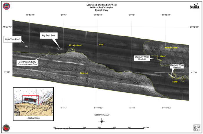
Numerous Ohio Sea Grant publications document the construction history of each of these reefs. The first set of reefs to be constructed were demonstration projects built offshore of both Lorain and Lakewood Ohio. At each location multiple reef mounds were built within a general area. The second set of reefs was built using concrete rubble from the destruction of the old Cleveland Stadium. Two reefs were built on the west side of Cleveland, near the Perkins Beach area of Edgewater State Park and a single reef was built on the east side of Cleveland near Wildwood Park.
Sidescan sonar operates on the principle that sound impulses transmitted underwater produce echoes or reflections from objects and materials on the bottom of the lake, which vary in intensity based, in large part, on the density of the material. This varying of intensity produces light and dark areas on the record called backscatter. The side scan system uses the return from transmitted sound pulses to produce a continuous acoustic backscatter record of the lake bottom along the survey trackline. The side scan records were collected with navigation data and digitized in the field using a Triton Elics Data Acquisition system, then post-processed in the office to geo-reference each record, correct for distortion and assemble side-by-side into a mosaic. These side scan mosaics were then imported into ArcviewÒ Geographic Information System software. Physical and visual sample data were then used to assign physical characteristics to areas of similar backscatter on the mosaiced maps to describe substrates on the bottom surface. The GIS software projects the mosaics as a map is projected and provides a layout which allows attributes and latitude/longitude lines to be added. The resulting image/map produced are reasonably accurate and provide a graphic view of the reef. On these maps, the relief of objects can be interpreted by looking at the shape of the acoustic shadow produced by the object. Similar to a light shadow, the longer the shadow the higher the object protrudes from the surrounding surface at a given distance and angle from the transducer (sound source and receiver). Details of the top and front surfaces can be seen in the patterns of light and dark on the mosaicked record. On these records the light areas are areas where relatively more sound is returned to the sidescan sonar transducer and dark areas are where little to no sound was returned.
Equipment used on the project included a dual frequency Klein 595Ò system and a Triton Elics Data Acquisition SystemÒ for acquiring and processing the records. The Differential Geographic Positioning System was employed for navigation utilizing a Trimble DSM-212H DGPS receiver which is capable of receiving updates at 10 Hz (10 times per second). Due to the close proximity of the track lines, Trimble HydroPro Hydrographic Survey software employed on a laptop received the DGPS signals and calculated the offset and layback distances between the side scan transducer and the DGPS antenna. A computerized Raytheon autopilot was also utilized on this project to provide minimal movement of the boat, straight track lines in a very tight survey pattern and removed the need for another person to steer. Both 100 and 500 kHz frequencies from the Klein 595Ò system were recorded but only the more detailed 500 kHz records were used to construct all mosaics. At each reef complex the first sidescan traverses were made using the 150-meter range. This records the acoustic bottom characteristics out to 150 meters from each side of the transducer.
During the field visit, a second set of closely spaced traverses over each individual artificial reef location was made using the 75-meter range. The shorter range was selected to provide detailed records that would be used to characterize each particular artificial reef.
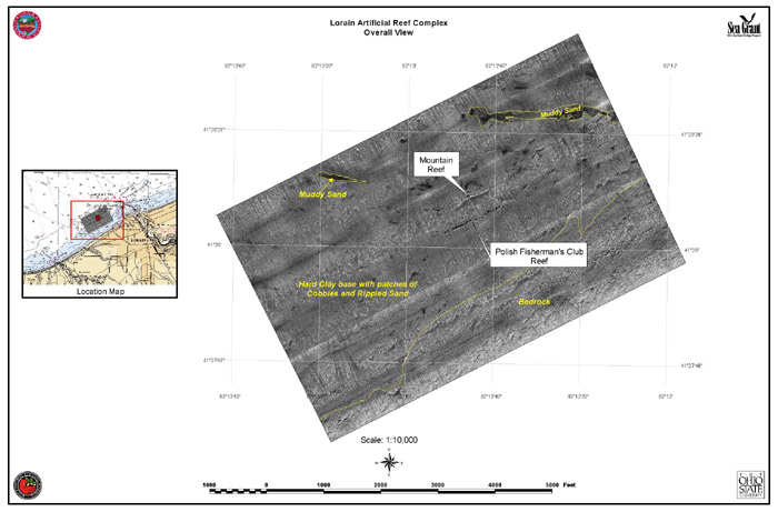
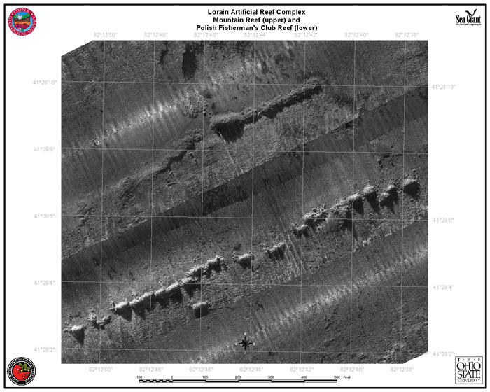
There are two reefs listed off of Lorain as part of the Lorain artificial reef complex. The nearshore reef is the Polish Fishermans Club Reef and was built about 1 mile west of Lorain Harbor, about ¾ mile offshore. It is a series of dump mounds in a serpentine form that provide relief on a nearly featureless bottom. The dump mounds generally range in height from about 3 feet to 6 feet. The other artificial reef in this complex is Mountain Reef. It is about 300 feet north of the Polish Fishermans Club Reef. Mountain Reef is a straight-line pile with a tall mound at the west end. Continuing to the west are a couple of low dump mounds offset toward the north and then a couple of more low mounds that are back in line with the main part of Mountain Reef. The height of crest of the main reef ranges from about 9 feet near the west end to 3 feet at the east end. Between Polish Fishermans Club Reef and Mountain Reef are two low dump mounds that were described as dump mistakes when the reefs were being constructed. All of these artificial reefs are very close together and they have all been placed on a hard clay surface that has cobbles and sandy areas. Inshore from the reefs is a poorly defined outcrop of bedrock (probably shale). Offshore and to the east of the reefs are a couple of narrow bands of muddy sand.
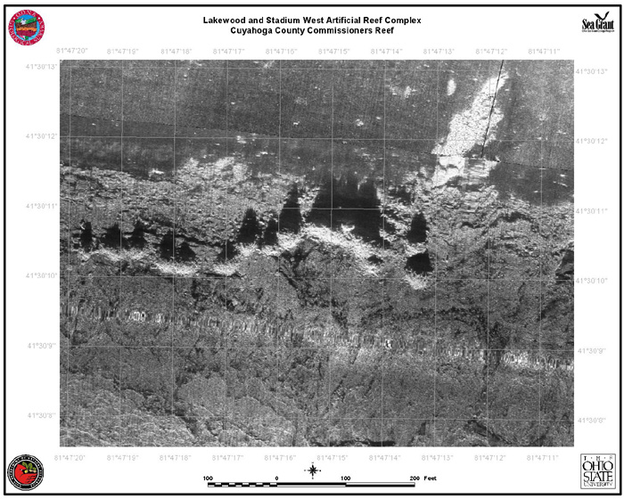
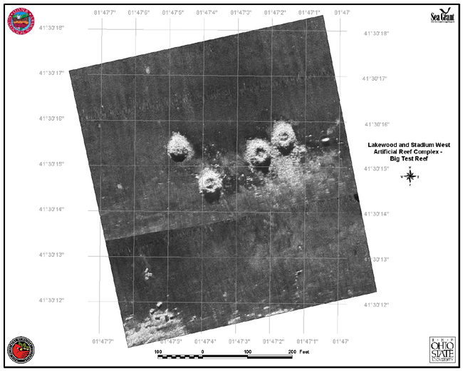
The Lakewood artificial reef complex includes the Cuyahoga County Commissioners Reef (CCC). It is about ½ mile offshore and about 2.6 miles east-northeast of the Rocky River Breakwater light. In the same area are the Little Test Reef, about 1300 feet to the west-northwest, and the Big Test Reef, about 1000 feet to the east-northeast of the Cuyahoga County Commissioners Reef. Another dumpsite was possible, Brattons Barge Reef, but it was not defined as a specific site and is probably included in the Cuyahoga County Commissioners Reef site. The Cuyahoga County Commissioners Reef is a curving series of continuous and discontinuous dump mounds of varying heights (range from 6 to 10 feet) that have been placed on a bedrock (shale) outcrop. Little Test Reef is made up of 6 low dump mounds (about 3 feet in height) that are about 30 to 40 feet in diameter which rest on a muddy bottom, less than 500 feet north of the edge of the bedrock outcrop. Big Test Reef is a group of four low mounds (about 5 feet in height) that are about 40 to 50 feet in diameter, these are also sited on the mud bottom and are also less than 500 feet north of the edge of the bedrock outcrop.
Information provided courtesy of Ohio Sea Grant. For more information on Ohio's Artificial Reefs visit the Ohio Sea Grant web site: Ohio Sea Grant